Interview by Mary Evans
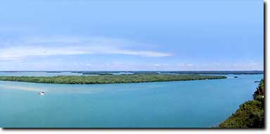
"The public boundary line between navigable tidal waters and upland is called the mean high water line." So began Howard Rhoads in a discussion of events in which he was involved as an attorney in the mid-1960s. Mr. Rhoads represented the Jack C. Windsor Trust in legal actions to determine where Windsor property ended and state property began. The question arose after the State of Florida settled a similar suit with Julius Wetstone.
The Wetstone property was a difficult case to resolve because the land in question was an island, Little Pine Island to be exact. At issue in that case, and subsequently in the Windsor case, was the question of whether a property's boundary line ran concurrent with the mean high water line. In an effort to answer that question, highly respected surveyor Carl Johnson was hired to survey Little Pine Island and identify the mean high water line. Johnson later testified in court that the mean high water line could not be pinpointed because of topographical inconsistencies. The attorney for the State of Florida, asked Johnson what , therefore, the boundary line of the property should be and he replied, under oath, "where the green stuff comes out of the blue stuff because that's what people think they're buying." In other words, Carl Johnson advocated the use of the meander line when the mean high water line could not be located. The court agreed, siding with Wetstone. Later, attorney Howard Rhoads referred to the precedent set in the Little Pine Island case in determining the boundary line of the Windsor property.
Howard Rhoads filed a suit that paralleled
Wetstone, however, surveyor Carl Johnson had passed away; his
former partner, Duane Hall, was hired to survey the Windsor property.
Beginning at the same earth monuments referred to in federal
government surveys from the 1800s, Hall completed his survey with
section lines that were consistent with the federal surveys. The
federal government had relied on the same section lines when it
conveyed title of those lands to the State of Florida. Furthermore,
Mr. Windsor had a federal patent for the land which relied, also, on
the section lines in the federal surveys.
As in the Little Pine Island case,
representatives from the State of Florida wanted to delineate a mean
high water line to resolve the "Windsor" problem. Duane Hall,
however, could not pinpoint a mean high water line, just as Carl
Johnson could not determine one several years earlier at Little Pine
Island. Hall was able to suggest an approximate mean high water line,
though that was of little help in determining the boundary line of
the property. According to Howard Rhoads, representatives from the
State recognized that he, as the same attorney from Little Pine
Island, had an excellent chance of winning this case as well. Hence,
the State of Florida offered a settlement.
Using the Hall survey, Hall and a
representative of the State of Florida redrew boundary lines for the
Windsor property. To arrive at a mutually satisfactory agreement, Mr.
Windsor would have to give some of his property to the State and the
State would have to give some of its property in return. Although Mr.
Windsor would lose roughly two hundred acres in the deal, he agreed
as did the State of Florida. Deeds were exchanged and the case was
dismissed with prejudice, or, to translate legal terminology into
more understandable terms, it was over with once and for all. Or so
they thought.
"So then he was in contact with the [State] in regard to development of this property because the State was aware that one of the purposes of identifying the boundary line was so that an owner could sell it to a developer and it could be used. This was not simply an academic exercise." Thus, the boundary line to the property was determined and Mr. Windsor began marketing it to potential developers. "So the Windsor group was now approached by Mr. Troutman who wanted to buy this particular property, which at that time encompassed fifty-two hundred acres" Mr. Rhoads said. Windsor took back a mortgage from Troutman who was informed that the land was "very sensitive" and that he should develop it in a very "responsible way." Troutman inquired as to whom he should hire as advisors and he was referred to Dr. Durbin Tab and Dr. Eric Heald, both of the University of Miami School of Marine and Atmospheric Science.
Word soon got out of Troutman's plans for
development and the public learned of the agreement between Windsor
and the State. Conservationists reacted sharply charging that Duane
Hall's survey was grossly inaccurate. Howard Rhoads recalls that the
Lee County Conservation Association argued the mean high water line
was much further inland at some sand flats. They further argued that
Windsor acquired property which the State did not have the right to
transfer and, furthermore, the land in question was highly sensitive
and should have been preserved. The Lee County Conservation
Association filed a law suit against Windsor, Troutman and the State
of Florida saying a grave mistake had been made. According to Howard
Rhoads, "they did not have standing to set aside a lawsuit to which
they were not parties. The Cabinet represented the public, not the
conservationists. The Cabinet was not interested in setting this
aside. This was a lawsuit that was settled in court and normally,
unless some grave error is made, the courts are not going to get
involved in setting things aside that have been decided. Unless, of
course, a mistake had been made of grave significance. We also
pointed out to the trial judge that no one who represented the public
was saying a mistake had been made, only some third party was saying
it and they had no legal standing to upset this particular
situation." Although the case was thrown out of court, Troutman
questioned whether a mistake was made by which Windsor had acquired
State lands.
Although no mistake ever was identified, a black cloud hung over Troutman's development plans. Not surprisingly, his application for a Development of Regional Impact was denied. Howard Rhoads filed an appeal in the First District Court of Appeals which determined that the State and County were disallowing development because they were trying to preserve the mangroves. The Court of Appeals demanded the State and County either furnish the development permit or, within 30 days, initiate eminent domain proceedings to acquire the property. The State and County, however, filed an appeal at the Florida Supreme Court which reversed the lower court's decision. While the Supreme Court rejected Troutman's initial plan for development, they did not say that any future plans for development would be rejected. Windsor and Troutman knew, however, that without a resolution to the problem, neither would be able to acquire development permits. With this in mind, Howard Rhoads approached several Lee county commissioners and explained how his clients were prepared to continue filing development plans, year after year. Clearly, however, the State wanted to preserve the property. The controversy finally ended, roughly ten years after it first had begun, when the property was placed on the list of endangered lands and purchased from Windsor.
|
|
|